
|
| ||
Last updated on 12/05/04 |
     
|
1. If faced with very strong straight line winds, try to position and face your vehicle in the direction the wind is blowing from. This keeps the wind from blowing your vehicle over by creating less surface area for the wind to hit. Vehicles usually get blown over when the wind is hitting them from the side. When you face the wind, the wind will be blowing toward the front of your vehicle making it extremely difficult to turn over. This tip is not intended for tornadic winds. 2. Never chase alone. Even if you are an experienced chaser, chasing alone can pose some major problems. When your alone, driving is the number one priority. Chasing alone and driving don't mix. Fumbling with maps, a phone, and cameras, along with looking at the sky can spell trouble. Trust me I have done it!! 3. Always have some kind of communication equipment...a phone which is a must have item, ham radio, and scanner. The phone comes in handy when your out in the middle of nowhere and you run out of gas or get stuck in mud. Trust me when its been raining and you pull off the road, it can get you stuck quickly. A PHONE IS A MUST WHEN CHASING! Much more important than a scanner because you can't contact people with a scanner when your stuck or out of gas. Ok, now to the weather scanner and ham radio. A weather scanner and ham radio is very important because it relays information to the chaser about the current storm situations. Tornado watches, tornado warnings, size of hail, the counties affected, and so on. 4. Pay special attention to water on the road (hydroplaning). This can get you in big trouble if you are rushing to get to a storm and there is water on the road. Water gets between your tires and the road and causes you to lose control very quickly and easily. Slow down when there is water on the road because I can bet that the nice looking supercell your trying to get to is not worth your life or the possibility of winding up in the bar ditch with a damaged vehicle. 5. Putting rain-x on your windshield before a chase is a very good idea. This does a very good job of shedding water off of your windshield when you get caught in heavy rain. It drastically improves your visibility when driving and most of the time you don't even have to use your windshield wipers and I bet the quality of your video will improve. You don't see windshield wipers in your video every second or so which is always a good thing. 6. When pulling off the road, always make sure you pick a good spot to stop. Never stop in the middle of the road like some people I have seen (not mentioning any names). I don't care if there's an f5 tornado and you have to stop right then to get video, don't stop in the middle of the road. Pull off the road all the way, preferably on a side road to get the video. Never stop in the middle of the road under an overpass to get shelter from hail either. I have seen this countless numbers of times. This puts others in danger that may need to keep going down the road. If your stopped in the road, emergency vehicles that may need to go by can't do it if your in the way. 7. Always keep at least a half tank of gas in your vehicle if possible. Getting very low on fuel when a tornado is on the ground is not very wise. Not only will you possibly have to cut the chase short but how would it feel to run out of gas with a large tornado slowly drifting off in the distance and you not being able to go after it. Or maybe running out of gas with a large tornado coming straight at you! Now that would not be a good feeling. Another case would be getting low on fuel and getting to a gas pump only to find out that the electricity is off and the next town is 50 miles away! Yes folks, gas pumps run on electricity! 8. Be aware of hail on the road. Hail on the road can pose some major problems if your going too fast and not aware it's even there. Driving on hail is just like driving on ball bearings, you have no control at all. If hail is on the road slow down and take your time. Getting video of a tornado is not as important as your safety and risking the possibility of damaging your vehicle in an accident. One thing to note, watch out for hail fog. Hail on the road can create fog that can drastically reduce your visibility, so slow down and take your time. 9. Be aware of other drivers on the road. They say that the most dangerous part of storm chasing is driving. I believe that is 100% true. Watch out for other chasers going fast or not paying attention to their surroundings. Slowing down yourself and paying attention will keep others from having to worry about you while out enjoying mother nature. NOTE: If you chase at night please drive at a safe speed because not knowing the roads, along with high speeds and blinding rain can be disastrous. 10. Never core punch the storm to get into position. Core punching is driving through the heavy rain and large hail to get into position to see the updraft. While core punching not only can get your windows broken out, you can easily get caught in a rain wrapped tornado. NEVER EVER CORE PUNCH! IT'S TOO RISKY. 11. Carry a small first-aid kit with you. You never know when you might need a band-aid, some ointment, or some aspirin when out in the field. NOTE: Carrying mosquito spray is a good idea when chasing. They can be a real nuisance when trying to take video or still pictures. Water tends to puddle up in areas next to the road and that's where mosquito's breed. Be prepared and stay focused on hitting that shutter button or record button instead of those pesky mosquito's. 12. WATCH FOR SNAKES! When you pull over on the side of the road and get out to get a still shot or some video of that developing wall cloud, make sure you look down and keep an eye out for snakes. I know they are the last thing on your mind at the time but they can ruin a chase and send you to the hospital in a hurry. Rattlesnakes are very abundant here in the great plains. 13. Always pay special attention to lightning. Lightning can pose a serious threat to chasers if not taken seriously. If you can hear thunder then you are at risk of getting struck by lightning. Stay inside your vehicle as much as possible when there is a threat of lightning in the area. I have a monopod set up in my vehicle so I can take video out of the rain and lightning. I have it mounted to my floorboard and I don't know what I would do without it. If lightning is eminent and your caught outside, crouch down on the balls of your feet for the best protection. 14. Know CPR and first-aid. This can come in very handy if someone is struck by lightning or for people that need immediate help that have just been hit by a tornado.
CHASING STRATEGIES: VERY IMPORTANT FOR THE BIG SHOW!
1. Always get to your target area before storms initiate. Sitting in your target area a couple of hours before storms initiate is a lot better than chasing them all day and never quite catching up with them, which I have done plenty of times. Having a few hours before storms initiate gives you time to take some photos, make sure all of your equipment is functioning properly, and gives you time to enjoy the scenery and enjoy the day without having to rush, especially if your in the right target area to begin with. 2.STORM POSITIONING: GOOD CONTRAST AND STAYING AWAY FROM HAIL AND PRECIP.
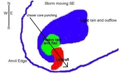
B. With a SE moving storm, position yourself to the S or SE of the storm. This keeps you out of the rain and hail and gives you good contrast.
C. With an E moving storm, position yourself to the S of the storm. This keeps you out of large hail and heavy rain while giving you fairly descent contrast.
D. With a S moving storm, position yourself to the E of the storm. You will need to keep moving south fairly often or you will be in light to moderate rain quite often.
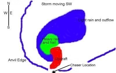
E. With a SW moving storm, position yourself to the S of the storm. This keeps the hail and heavy rain to your N and NW.
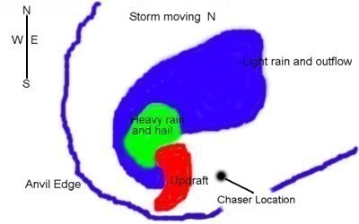
F. With a N moving storm, position yourself to the E of the storm. This keeps the hail and rain to your N and NW.
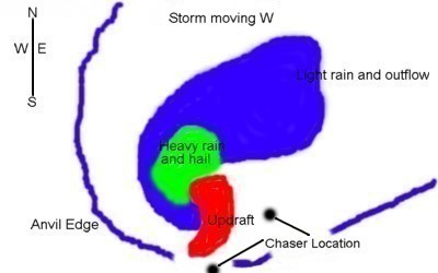
G. With a W moving storm, position yourself to the S/SE of the storm. This keeps the rain and hail to your N/NW and gives you good visibility of the updraft.
3. Pay attention to the dryline. WEST OF DRYLINE EAST OF THE DRYLINE 1. Strong west or southwest winds 1. S or SE winds 2. Clearing skies 2. Hazy or cloudy skies 3. Warm temps 3. Warm temps 4. Low moisture 4. High moisture content Try to stay at least 30 miles or so to the east of the dryline so storms can fire on the dryline and come to you. 4. Use road networking wisely to get close to a supercell in the least amount of time. Doing this wisely will get you close as quickly as possible, plus it will consume less gas in the process.
EQUIPMENT CHECKLIST: AN IMPORTANT LIST TO GO OVER BEFORE LEAVING HOME! This is a very important list to go over before leaving home. Forgetting an item or two can turn a good chase into a disaster. *Don't forget maps. You definitely don't want to be out chasing without knowing what the road network is like. If you go chasing and find that you forgot your maps, then you better call the chase off right then unless you know the area like the back of your hand. Having a tornado or large hail bearing down on you while not knowing the road network is bad news. *Fill up your tank before leaving home. Even if you have a half of a tank, go ahead and fill it up all the way to save time. You may be getting close to empty when you have the time or opportunity to fill it up while chasing. Nothing is worse than being on a great storm that's about to produce a tornado and having to leave it to go fill your vehicle up with gas. Trust me, I have been there! *Don't forget your wallet, cash, debit/credit cards. Taking a checkbook is also a good idea. Filling up your tank and going in to pay and realizing that your wallet was left at home is never a good thing. Especially if you have a supercell close by. *Rain-x your windshield before you leave. This saves time. Rain-x will shed rain off of your windshield to give you better visibility and it also makes your video look better. You know, you don't have windshield wipers in your video every second or so. That's right, with rain-x you don't even need to use your wipers when it's raining. It works that good! The new rain-x wax works really well. *Check spare tire and check all other tires before leaving. Sometimes flats occur while chasing.. You pull off to the side of the road to check out the storm and ooops you just ran over a nail. Or, you are in a town that just got hit by a tornado and there's debris in the road, which probably includes a lot of nails. If either of these occur and you find that your spare is no good, then your chase day just went down the drain. *Check your oil level before leaving home. You don't want to be chasing with a low oil level which can damage your vehicle. You will be spending your hard earned money on engine repair instead of that nice digital camera you saw on the internet the other day. *Don't forget a cell phone or bag phone. This is very important. I would recommend not chasing until you acquire some sort of communication device. You need some sort of communication if you get into trouble. If you have car trouble, get a flat, or get stuck, you need to have the equipment to contact someone. If your chasing for the NWS or a TV station like I do, you need a cell or bag phone to relay information to them so they can give advanced warning and hopefully save life and property. *Fix-a-flat is a good thing to take along. I chased for almost 2 years without carrying this item. This works really well if you have a slow leak in your tire. If you have a slow leak and there's a tornado or hail core bearing down on you, you need to get that tire aired up and get out of there quickly. I have not needed to use this yet but I will not go on a chase without it! Buy a couple and keep under the seats of your vehicle. If you ever need to use it, you will be happy that you had it. When you get the chance, get that tire fixed right. *Don't forget a jacket. It can go from 80 to 55 or 60 pretty quickly when you get cool outflow from T-storms. Taking photos or video of that beautiful shelf cloud is no fun if your cold. *Take along a flashlight with extra batteries. Suppose you had a great chase day and got a large tornado on video and now your on your way home. Your in a good mood and breathing in the night air and bump, bump, bump, you just got a flat tire. It's dark outside and your in the middle of nowhere. This is when a good flashlight comes in handy. Or suppose your having car trouble at night and need light to try to find out what's wrong. On a lighter note, suppose you are taking some lightning photos and need too have some light to check the settings on your camera. You check the settings and slip the flashlight in your pocket. *Don't forget a tripod and (window pod if you have one) for your still camera or video camera. (Nobody likes shaky video or blurred still images). Scroll down for my photography tips section. *Don't forget Windex and paper towels. Bugs on your windshield makes your video look pretty bad. Do this when gassing up or waiting for storms to develop. You have all seen it. You have bugs all over your windshield and it starts to rain and you turn on your windshield wipers. Well, the rain stops and now you have a mess that you can hardly see through, especially if driving into the sun. KEEP THOSE WINDSHIELDS CLEAN WHENEVER POSSIBLE! *Above all, don't forget your video camera, still camera, along with extra film (memory sticks) and extra charged up batteries. Also don't forget extra tapes for your video camera. The day you forget to take these items or forget to charge your batteries up will be the day you see a picturesque elephant trunk tornado snaking along the countryside. *Here's a tip. Instead of stopping at gas stations to get drinks and snacks, taking along a cooler with drinks and snacks will save time and be more convenient for you when your out in the middle of nowhere and need an energy boost . *Carry along some basic tools with you. If you do happen to get a flat or have car trouble, some basic tools like wrenches, screwdrivers, electrical tape, and other items can possibly save the day. Remember, your #1 tool in storm chasing is your vehicle, so take care of it and be prepared to fix it in the event of an emergency.
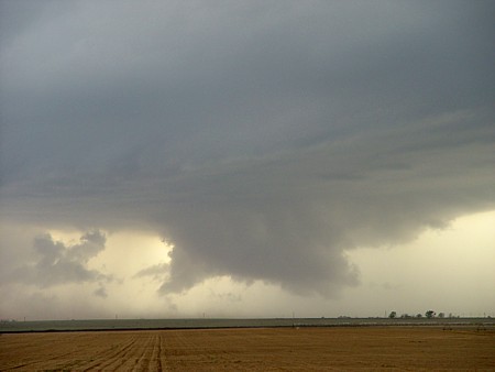
VIDEO AND PHOTOGRAPHY TIPS: MAKE THE MOST OF YOUR STORM CHASING MEMORIES. While out chasing, most of us use some sort of device for recording images such as video cameras and still cameras. It is very important to know how to use these devices in the most productive way possible. Here are a few tips on how to get the best images from your video and still camera. Remember that your images are memories of that special chase so being able to take the best video or still shots is of extreme importance. Enough of the preaching, let's get on with the tips. * Whenever possible ALWAYS use a tripod for your video and still shots. Nobody likes shaky video or blurry still shots. A tripod is a very important item in a chasers bag of goodies. Having your video on a tripod not only makes for great footage, it also allows you to do other things like taking still shots or getting on the phone and telling your good buddy that you have a large tornado on the ground. * If your camera has the option, I always recommend using manual focus. Your using auto focus and get video of a tornado when a rain drop hits your lens. Well, now your camera focuses on that little rain drop instead of that big tornado!. Also when using auto focus the lens tends to focus on different things a lot which makes the video blurry at times. * Focusing using manual focus is pretty easy but you have to do it right every time. Say you have a wall cloud developing and want to get video of it. Zoom in on the wall cloud and use the focus ring until the subject is in focus, then zoom back out. Now everything will be in focus from the widest angle to the point where you zoomed in. If you want to zoom in even closer than you did before you will have to zoom in to the desired point and re-focus the camera. *When zooming in and out with your video camera, try to do it smoothly and slowly and don't do it very often. You have a tornado on the ground and see debris so you zoom in close for a couple of seconds then zoom back out and then zoon back in again. That's not good video. Zoom in smoothly and slowly on the debris and keep it there for a minute or so then zoom back out slowly and smoothly. *Always use at least a 20% ground reference! This is very important in good video or still shots. You are taking video or still shots of a wall cloud and get little or no ground reference at all. That's bad documentation. A ground reference gives an indication of how low that wall cloud is or how wide the wall cloud is. You don't take a photo of that classic 57 Chevy without showing the wheels, so don't take a photo of that classic supercell without showing some ground reference. It's ok to get close-up video of the cool looking mammatus or boiling updraft but make sure to use a ground reference on the wall cloud, mesosyclone, and especially the tornado shots!
Wall cloud with 20% ground reference
Wall cloud with little or no ground reference (You tell me which one looks better)!
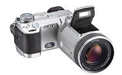
*You may ask, why do I need to use a tripod for still photography? Generally when you are you taking still shots of storms, the lighting is fairly low. Thus, the shutter is open longer in the camera to let the right amount of light in. Well, when you take shots without a tripod the camera is moving around while the shutter is open. I'm sure you can hold a camera pretty still but any slight movement can make an image become blurry. If you have no time for a tripod, rest the still camera on the hood of your car or anything else that is steady. This obviously works for video cameras as well. Oh by the way, a tripod is MANDATORY for lightning photography. *This is more of a recommendation than a tip. I recommend anyone interested in still photography to get a good digital camera. Most of the images of mine that you see on this website were taken with a Sony f717 digital camera. Digital cameras are fairly expensive but not having to pay for film or processing plus the benefit of seeing your image instantly is worth the higher price. Read up on digital cameras and consider getting one if your like me and take a lot of still shots while chasing those majestic supercells. Speaking for myself, I will never go back to film photography again! *Always double check to make sure your camera is recording! Get in a habit of doing this every time you push the record button. Triple check this if you have to because if you thought you pushed that record button, you will find out if you did or not when you get home to a blank tv screen instead of an F5 tornado. This would be the ultimate in "I thought I did" screw ups. * Keep your lenses clean. Small water drops or fingerprints will show up in your video and still shots. Take along some small soft cloths in your camera or video bag to take care of this problem. Keeping your equipment clean will give you trouble free shooting with the best images possible. *Shoot lots of footage. You can never shoot too much footage or take too many still shots. Just be sure to have extra memory sticks and charged up batteries along with extra tapes for your video camera. *Narrate the video. When you watch your video next year of yourself driving down the road with that supercell in view, how will you remember where you were? Narrate your video by saying where you are and what time of day it is. If you get a developing tornado say something like, "Ok, I have a tornado on the ground. Its about 6:30pm May 15th 2003. I am located in Sherman county Texas looking west at a large tornado on the ground. The tornado just developed in the last few minutes and right now it's in open country but it looks to be heading toward the town of Stratford. The SPC has this area in a high risk today and it shows! The point is to make the video interesting and document time, date, and location along with other interesting points. Just use your imagination and your video won't be boring. *Make sure your equipment is in good condition. Inspect your video camera and still camera before leaving home. If you can afford it, try to have a back-up video and still camera in case something goes wrong with one of them. You happen to drop your video camera on the ground and it shatters! Then on cue a pretty little tornado forms right before your eyes. You know Newton's theory, "If it can happen it probably will".
MISCELLANEOUS TIPS: THINGS THAT MIGHT HELP YOU WHILE OUT CHASING. 1. Reporting hail size to the NWS or TV station pea-0.25 Don't use marble as a size. Marbles come in different sizes so say slightly smaller than penny size-0.50 Penny-0.75 Nickel-0.88 Quarter-1.00 Half Dollar-1.25 Ping Pong/Walnut-1.50 Golf Ball-1.75 Hen Egg-2.00 Tennis Ball-2.50 Baseball-2.75 Teacup-3.00 Grapefruit-4.00 Softball-4.50
Severe T-storm Criteria Tornado, 3/4 inch hail or larger, or 58mph winds or greater. Reporting Criteria to the NWS or TV station 1. Report your exact location 2. Report the direction your looking 3. Report where the event is occurring 4. Report what you have seen 5. Report the movement of the event 6. Repeat When out chasing, it is important to know the speed and direction of the wind in order to determine whether the storm is taking in inflow or producing outflow. INFLOW is usually warm, moist air being pulled into the updraft from a southerly or southeasterly direction. OUTFLOW is cool, dry air being fanned out from a Northerly direction in the outflow region of a T-storm. example would be cool air from a shelf cloud. Severe Weather Watches And Warnings Definitions: Flood Watch: High flow or overflow of water from a river is possible in the given time period. It can also apply to heavy runoff or drainage of water into low-lying areas. These watches are generally issued for flooding that is expected to occur at least 6 hours after heavy rains have ended. Flood Warning: Flooding conditions are actually occurring or are imminent in the warning area. Flash Flood Watch: Flash flooding is possible in or close to the watch area. Flash Flood Watches are generally issued for flooding that is expected to occur within 6 hours after heavy rains have ended. Flash Flood Warning: Flash flooding is actually occurring or imminent in the warning area. Tornado Watch: Conditions are favorable for the development of tornadoes in and close to the watch area. Tornado Warning: A tornado has actually been sighted by spotters or indicated on radar and is occurring or imminent in the warning area. Severe Thunderstorm Watch: Conditions are favorable for the development of severe thunderstorms in and close to the watch area. Severe Thunderstorm Warning: A severe thunderstorm has actually been observed by spotters or indicated on radar, and is occurring or imminent in the warning area. FUJITA SCALE
Spotter Glossary Accessory Clouds Anvil Collar Cloud Cumulonimbus Cloud Cumulus Cloud Downdraft Flanking Line Flash Flooding Front Funnel Cloud Gust Front Hail Hook Echo Lightning Mamma Clouds Precipitation Shaft Rain-Free Base River Flood Roll Cloud Scud Clouds Severe Thunderstorm Straight Line Winds Shelf Cloud Tail Cloud Thunderstorm Tornado Updraft Virga Wall Clouds
IF YOU HAVE ANY IDEAS OR
TIPS THAT I MAY HAVE MISSED, PLEASE
E-MAIL ME
AND I WILL POST THEM |
This site was last updated 12/05/04

 Copyright 2003 Jason Boggs
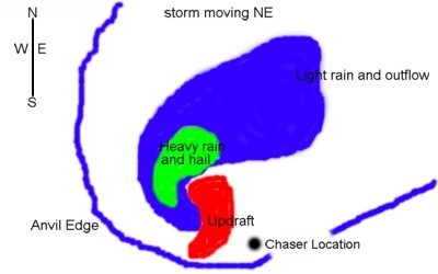


 Copyright 2003 Jason Boggs
 Copyright 2003 Jason Boggs.
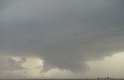 Copyright 2003 Jason Boggs.